Land Change Modeler 1.0

The Land Change Modeler is a land cover change analysis and prediction software
5 
Rating
Your vote:
Latest version:
1.0 See all
Developer:
Screenshots
1 / 1
Commercial
Download

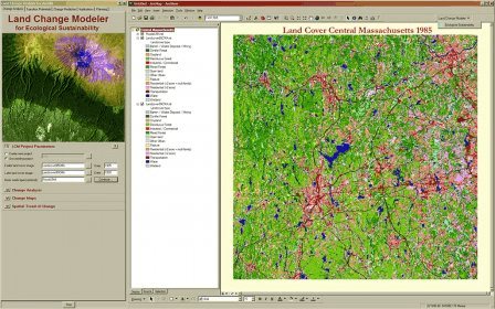
The Land Change Modeler is revolutionary land cover change analysis and prediction software which also incorporates tools that allow you to analyze, measure and project the impacts on habitat and biodiversity. Land Change Modeler includes a suite of intelligent tools that address the complexities of change analysis, resource management and habitat assessment while maintaining a simple and automated workflow. The Land Change Modeler is included within the IDRISI GIS and Image Processing software and is available as a software extension for use with ESRI’s ArcGIS product.

Comments

5 stars
3
4 stars
0
3 stars
0
2 stars
0
1 stars
0
User

Your vote:

Related software

Wizard Land
Wizard Land
rating

Puzzle game in which you must help the wizard save the world.

Quest Toad Data Modeler
rating

Deploys changes to one or more to databases and creates database structures.

MEP Modeler AC21 INT
rating

Models and visualize the MEP systems in 3D and eliminate potential collisions.

SimCLIM
SimCLIM
rating

It is a tool designed to perform the assessment of risks from climate changes.

REDD Abacus SP
REDD Abacus SP
rating

You can estimate emission from land use and land cover changes.